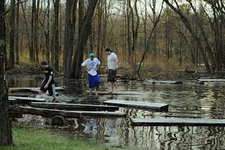
Predicted times and flood level projections are always... a fact of guessing and mere prediction since the situation is getting worse and not subsiding.
I drove along the edge on both sides in three towns since early this morning, not realizing what the day would bring since I live in minor remote area with no local tv or radio broadcast due to signal interference from a natural element.... a mountain.
I observed in one location tonight, the waters edge is about three feet from pouring over onto the road. The other side of the river... in a small shallow bowl like setting... it was approximately 18 inches from
spilling onto the road with a notable amount of debris collecting and pooling along the edge. As for bridges... only two that I would risk driving over right now. Another bridge has one lane that was warded off this last winter... making it a one lane bridge... and NO one could ever make me drive across it now. It appears that the state, local government or who ever is in charge of repairs is doing major work on that bridge too and is clearing out space and building a new bridge next to the old bridge.
I don't know for sure... it's just a guess. Something tells me that most of that work will be wiped away by morning though. Beyond that note - I will drive miles out of the way over another seemingly safer bridge.
Lots of homes along the river's edge have approximately 2-4 feet of water in them.
I saw kids toys floating away, lawn furniture and HUGE massive logs and a lot of debris.... it's bad. I feel bad for homeowners and others who have property along the river.
The history of the town(s) and landscape goes back to the days of older Adirondack establishment by means of logging...
So, while watching this flood develop and leave it's mark on mass scale, my mind could not help but wander back to the possibilities of years past when local towns were completely wiped away and rebuilt before civil engineers built a dam on an adjacent waterway.
That waterway is usually it's a trickle of a stream where fishermen can be seen in hip waders while hoping to catch that fresh river trout.
A dam located upstream is opened to release some pressure around noon or 1pm'ish from one waterway, spilling into the other river.
It's quite remarkable watching the water rage by with huge logs and small islands of conglomerated bunches of branches, trees, and who knows what else from one river as it passes the other bypass... Well, it's not passing by now... it's filling it up since the river is swelling further downstream.. So, back-flow is occurring. All that.... adds to the turbulent current and destructive flood.
It's quite remarkable and unforgettable.
Tomorrow morning I will try to wake early and set out in exploration before any daily business, camera in hand - ready to capture any rare moments of history.
This will be a year to remember.
Peace.
(other than that... Life has been peaceful, yet exciting and productive. All is well.)


